Here Comes The Snow! Some Areas Along Minnesota’s North Shore Could See A Foot Or More This Week
For the winter haters out there - if you're looking for a positive spin, this will help get things feeling more festive for the Christmas City of the North Parade and the opening of Bentleyville this coming weekend.
After the storm system late last week that brought a couple of inches of rain before ushering in our wintery temperatures, it definitely started feeling more like winter. Now, this week's snowfall potential will bring the look of things to match the feel of it all.
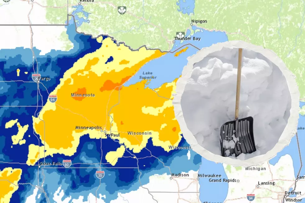
The National Weather Service office in Duluth published what they expect the Northland to get in the way of snowfall totals over the course of the first few days of this week, and some places are in line to get quite a bit!
How much snow will we get this week?
As is usually the case, it really depends on where you are. A large portion of the Northland won't see more than 1-3 inches of snow to kick off the new week. Again, as is often the case, Lake Superior will influence things near its shores, however.

The place in line to get the heaviest snowfall early this week is the area between Silver Bay and Grand Portage, along the North Shore. Because of this, the National Weather Service issued a winter weather advisory for a large part of the North Shore and Minnesota Arrowhead, with the area from around Tofte all the way up to Grand Portage falling under a winter storm warning through Tuesday afternoon.
The warned area could see anywhere from 6 to 14 or so inches of snow. In their snowfall forecast, the area that could see the heaviest snow is Grand Marais, with a forecasted snowfall amount of 14.4 inches!
What about the Twin Ports area?
Well, the Twin Ports is in an area that could see 4-6 inches of snow before the end of the day Tuesday, with the following being the forecasted totals for area towns:
- Duluth: 5.2 inches
- Cloquet: 4.2 inches
- Moose Lake: 3.9 inches
- Solon Springs: 3.2 inches
Even though these snowfall totals don't sound particularly daunting for the Twin Ports area, the combination of the light snow and cold conditions could lead to slippery roads over the next couple of days.
Add in the less scientific factor of many Northlanders getting their "winter driving legs" under them as the season gets underway, and extra caution on the roadways should 100% be exercised as you're out and about for the next few days.
What's next after the snow?
If you're wondering if the freshly-fallen snow will melt after we get it, worry not. It looks like it will stick around for a while.
After our biggest snow chances Monday and Tuesday, slight chances of snow persist Wednesday and Thursday, with a cooldown in the forecast for the rest of the week.
We'll see daytime highs go from around 30 Monday through Wednesday to around 20 degrees Thursday all the way through the weekend. Overnight lows will go from the teens above zero early this week to the single digits above zero to end the week.
All of that said, whatever snow we get should stick around as the Northland kicks off the holiday season Friday with the Christmas City of the North Parade and Saturday with the season's opening at Bentleyville at Bayfront Festival Park. How festive, right?
Things Everyone Knows About A Duluth-Superior Winter
More From MIX 108


