Jaw-Dropping Videos, Photos Captured Fury Of Minnesota Tornadoes This Week
Northern Minnesota was at the center of the strongest severe weather threat across the entire country on Wednesday, with several tornadoes, large hail, and damaging winds leaving their marks across parts of the state.
The Storm Prediction Center put a bullseye on Northern Minnesota for June 12, 2024, with the risk of up to baseball-sized hail, damaging winds up to 70 mph, and isolated tornadoes all in the forecast at the start of the day.
Being the area of greatest severe weather risk throughout the country, a number of storm chasers converged on Minnesota, looking to follow the storms that would erupt through the day.
Storms flared up Wednesday afternoon, and by the time things wrapped up on Wednesday night, reports of wind gusts up to 68 mph, hail up to 2.75 inches in diameter, and a handful of tornado warnings in places like Crow Wing, Aitkin, Carlton, Pine, Lake, and Cook Counties.
A radar-indicated map of the tracks of hail across the region shows multiple paths of large hail, with the largest reports in places like Marble, where they saw reports from people of 2.75-inch hail, and places like Chisholm and Backus where they saw 2.5-inch hail.
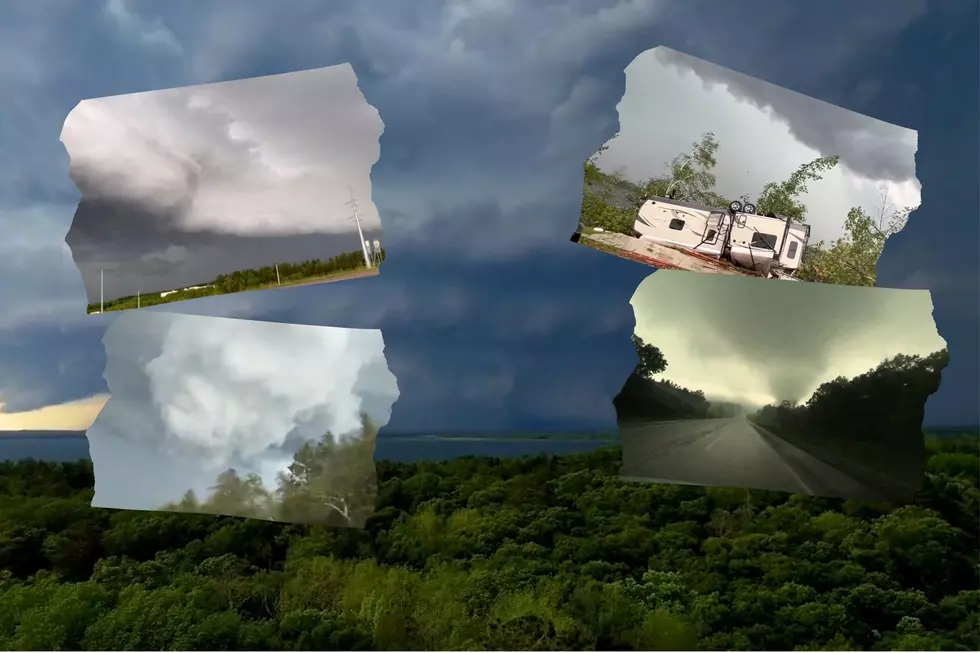
While the tornado-wared storm in far northeastern Minnesota didn't get much attention from storm chasers, a lot of footage and images were captured of the storm that ripped through the area between Crosslake and Aitkin.

Storm chaser Jason Bednar caught some footage of the tornado-warned storm near Crosslake, capturing his footage from an area near Breezy Point near Pelican Lake.
For one of his clips, he put a drone up in the air to capture the tornado-warned storm from near Breezy Point, showing the massive storm churn to the north in the Crosslake area as it continued its path southeast.
Jason also shared footage of the ground, showing the storm churn across Highway 3 near Pelican Lake.
Before the storms got to the Crosslake/Breezy Point area, storm chaser Ewan Newbold caught this photo of the storm cell to the northwest, just southwest of Pine River.
Well-known storm chaser Reed Timmer shared a compilation of some footage that includes some wild visuals of a tornadic storm east of Brainerd.
Storm chaser Brandon Copic caught lots of footage of a tornado in the Aikin area, showing a timelapse of some of his footage in one clip he shared.
In a separate clip, Brandon showed the tornado crossing Highway 210 near Aitkin at normal (non-timelapse). During his approach toward the tornado, you can hear him talking about his vehicle being hit by debris from the tornado.
Here's a look at the tornado further southeast, in the Glen area, which is just southeast of Aiktin by a few miles.
Egan Young shared a small tornado developing near Glen.
Chaser Kannon shared a shelf cloud ominously pressing through the St. Cloud area.
One of the most commonly shared visuals after the storm is some damage that was left behind near Clinker Lake by Crosby. The visuals include an overturned camper and several trees on the ground.
Further northwest, one of the staff with Bertha Boat Works shared video from on Whitefish Lake in the Crosslake area, showing lots of downed trees, docks flipped over, and a big mess along the shoreline of the lake.
Abby shared some images of trees down by her dad's cabin in the Aikin area
Here are some photos of trees snapped off in the Crosby area.
We also asked for photos from our listeners, and thankfully many people in the Twin Ports area didn't see much in the way of extreme damage. Here's a look at some of the photos shared with us.
Listener-Submitted Photos From June 12, 2024 Storms
Gallery Credit: Nick Cooper - TSM Duluth
More From MIX 108