Blizzard Potential: Next Week’s Storm May Bring Heavy Ice, Snow, Tropical Storm-Force Winds To Minnesota
Even hard-core snow-lovers are throwing up their hands in flaky despair. "Enough already Paul!" But wait, there's more (snow and ice) in the extended outlook for next week. We are less than half an inch away from a Top 5 Snowy Winter in the Twin Ports (127.9" now - if we get to 128.3" this winter will move up into #5 position). Terrific.
Weather drama today and tonight stays south of the Twin Ports with heaviest snows over the southern suburbs of the Twin Cities and southeastern Minnesota, where 8-10"+ may fall. We just get a glancing blow, with quiet weather this weekend into Monday.
Next week's storm could mutate into a blizzard, with heavy icing turning to snow and winds over 50 mph before tapering by Thursday morning. Details below:
The ECMWF (European) model prediction above is for accumulated sleet by next Thursday morning. Sleet = ice pellets, and as much as 1-2" of sleet is predicted with this next storm as warmer air aloft gets wrapped up into the circulation.
Next week's storm is forecast to track from near Denver to St. Cloud, then push over Lake Superior next Wednesday, whipping up powerful winds as high as 40-55 mph or higher. Surface temperatures will be below 32F, so any rain that gets tangled up in this storm will almost certainly freeze on contact, creating glace ice, and ECMWF predicts over a tenth of an inch of glaze ice from next week's system.
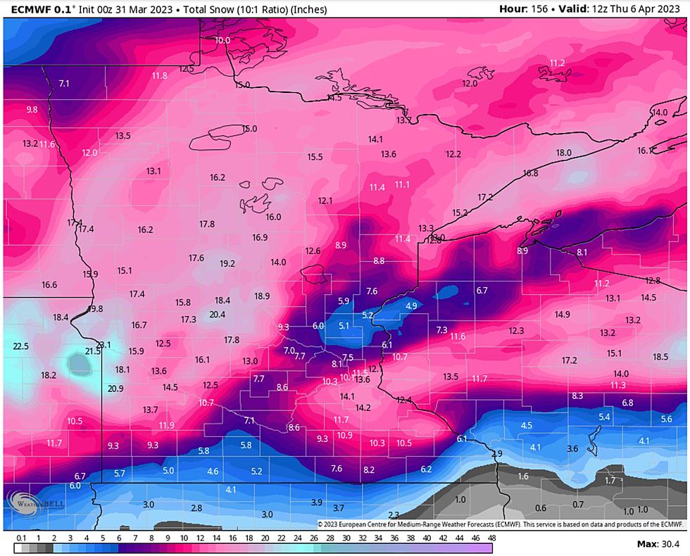
NOAA's GFS model is also predicting very significant snowfall totals, especially over roughly the northwestern half of Minnesota for Tuesday and Wednesday of next week. We can't rule out upwards of a foot of additional snow for much of the Northland at the tail end of the storm, but ice mixing in with the snow may keep snow totals down. Even so, travel will be messy and potentially treacherous by the middle of next week.

It's early (that needs to be emphasized over and over again). The details will change as the storm's track, moisture content and temperature profile of next week's storm morphs over time. The forecast may shift as newer (more accurate) data initializes the weather models, but ECMWF (above) is hinting at crazy, 30-60 mph wind gusts at the height of the storm next Tuesday night into Wednesday with windblown ice changing over to snow.
Snowy exhaustion has set in, but we aren't out of the snow-clogged woods just yet. At least one more (major) system next week, with significant icing and a potential for blizzard conditions, especially north and west of the Twin Port.
Stay tuned for more updates as the storm gets closer and details begin to crystallize.
I know, I'm ready for spring too.