Hazardous Weather Ahead: Latest On Freezing Rain, Snow This Weekend In Minnesota, Wisconsin
As we've been sharing throughout the week, there's a growing likelihood that this weekend's weather is going to be rough.
The picture the National Weather Service is painting across parts of Minnesota and Wisconsin isn't for a huge amount of snow, but rather a storm that includes freezing rain, mixed precipitation, snow, and wind that could all combine to make for tough travel conditions over the weekend.
And just for fun, we'll throw in some severe thunderstorm chance, because it's springtime in the Northland.
The area of greatest concern is in Northern Minnesota, where the first wave is expected to be freezing rain that could lead to ice accumulations, followed by snow to wrap up the weekend.
What areas are under weather watches and warnings?
Ahead of the incoming weather, the National Weather Service has issued a winter storm watch for a handful of Northern Minnesota counties from 6 am Friday through Sunday evening, including areas like Moose Lake, Duluth, Two Harbors, North Shore, and the Iron Range.

There's a winter weather advisory for some border counties in the far northern part of Minnesota, as well.

As the graphic above explains, there's also a marginal risk of severe thunderstorms in Northwestern Wisconsin on Friday, including in areas like Hayward, Ashland, and Park Falls, and places to the south and east.
What and when can we expect ice from freezing rain?
Freezing rain is expected to start early Friday morning, sometime after midnight in places like Moose Lake, the Twin Ports area, and on the Iron Range. Places to the far north could see snow to start, changing to mixed precipitation.
Areas to the south of the Twin Ports and into Wisconsin will see rain to start, and into the day on Friday.
Besides making things slippery for travel, accumulating ice along with expected windy conditions could lead to power outage issues due to power lines and tree branches covered in ice.
MORE: See listener-submitted photos of this week's Northern Lights across the Northland
The chances of accumulating ice before Saturday morning extend across much of Northern Minnesota and Wisconsin, with the area between Duluth, the Iron Range, and along the North Shore in line to see what could be the worst of the freezing rain.

Some areas seeing freezing rain could see a change to mixed precipitation through the later parts of Friday, before things calm down somewhat at the end of the first round of this two-act weather situation. Then there's another chance for ice this weekend further south.

Saturday and into Saturday night, the chances of accumulating ice shift further south, with the area jus north of the Twin Cities and through spots like Hayward and Phillips in Wisconsin seeing chances for accumulating ice from the second round of this storm.
How much snow will we get?
Things will shift to mostly snow through the day on Saturday and into Sunday, before wrapping up Sunday night during the second part of this weekend's storms.
While there isn't a high likelihood of seeing a foot of snow across the region, pockets of seeing as much as 6 or so inches of snow are possible in places.
This map doesn't show the full storm total (just through Sunday morning), but it shows chances of maybe 3-5 inches of snow in the Twin Ports area, 4-6 inches along much of the North Shore, and 4-7 inches along the South Shore.
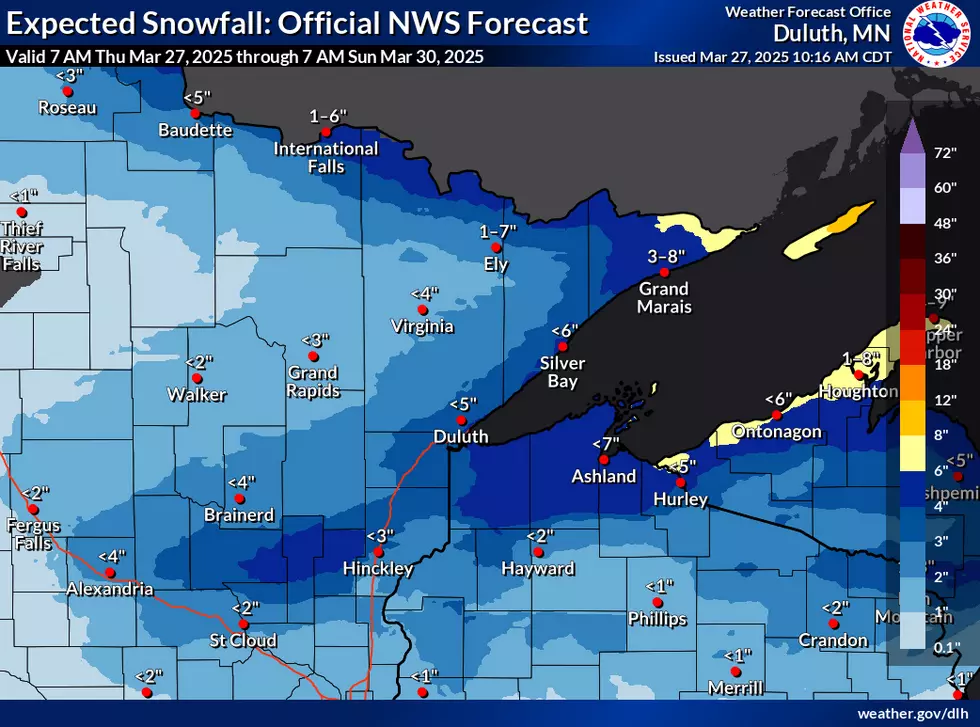
As I mentioned, this just looks at snow potential through 7 am on Sunday, and snow is expected to wrap up later in the day, so numbers higher than those on the map are possible by the time it all wraps up.
Earliest Ice-Out Dates Recorded On Popular Minnesota Lakes
Gallery Credit: Nick Cooper
More From MIX 108